|
Druid Hill Stone Circle
What the devil in Lowell?
Report: 9 March 2005 by Daniel V. Boudillion .
|
Druid Hill
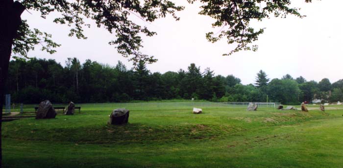
The Druid Hill Stone Circle is located off Gumpas Road
in Leblanc Park, at the corner of West Meadow and Gumpas, Lowell, Massachusetts.
It is on a promontory long known as Druids Hill or Bridgets Hill. The
circle is located at elevation 140', and is a half mile north of the Merrimack
River, elevation 100'.
According to archeologist John Pendergast in
1985:
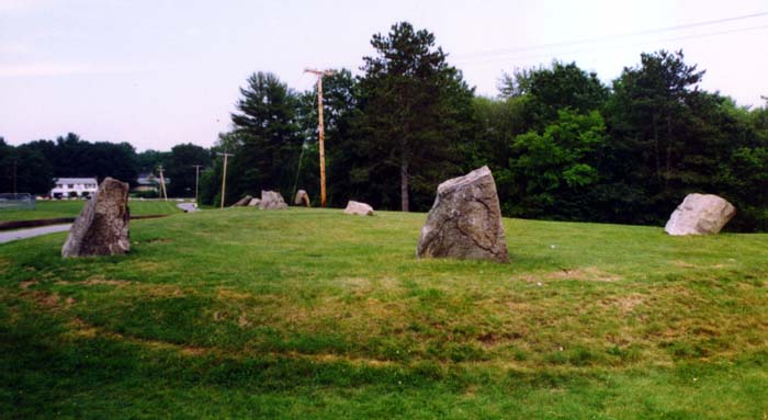
"The circle is 114 feet by 62 feet and is more
tear-drop or egg-shape than circular. It falls into a category established by
Aubrey Burl known as egg-shape #2. The circle of stones is on a mound
which averages 2 feet in height all of which is on a gently inclining hill.
There are two active springs in the area.
"The area appears in historical records as parts of
land grants as early as 1629, but passes from Indian land to private ownership
lands about twenty years later. The first European owner, John Webb, sold the
land to Thomas Varnum, whose family owned the land well into the 19th
century. It is unlikely that Puritan Mr. Varnum would name his hill after a
pagan Irish Saint.
"In 1915, an isolation hospital was constructed near
the circle. It was burned and razed in 1955. The area is now a municipal
park. The circle of stones is never referred to on maps or any other records.
... Not far from the site here is a stone chamber which has been determined to
be a habitation by a Boston University archeological team, but no dates for its
construction have been determined."

Druid Hill - Photo Courtesy of Edward Bochnak
Dorothy Hayden of the American Institute For
Archeological Research added in 1987:
"The Druid Hill Stone Circle consist of a raised
tear-drop shaped mound approximately one meter high [3.2'], with a dozen
monoliths ranged about it in a pattern typical of stone circles all over the
British Isles. At the western end, on level ground below the raised mound, lies
a large flat "recumbent" stone and top the southwest stands a huge "outlier"
monolith, both typical of European stone circle construction.
"No written recode of who built this mound and
megalithic complex, when or why it was built, appears to exist. In the memory
of elderly residents of the vicinity it has "always been there." Coupled with
this are the tantalizing references in old documents, first to Bridgets Hill
(the name Bridget being associated with witches), and then to Druid Hill.
"The locality of Druid Hill has an odd history; first
mentioned as field pasture on the edge of an Indian reservation in 1659, it was
acquired by Samuel Varnum in 1667 and remained in his family for 250 years. In
1906 a health camp was built on land directly adjacent to the stone circle
site. By 1916 work was begun upon a (tuberculosis) isolation hospital on the
land next to the stone circle site. This isolation hospital was opened in 1918
(two years before schedule because of the devastating influenza epidemic that
was raging through the area at the time). The hospital was razed in 1953 ands
the land became a public park. This part of the sites history is fairly well
documented, but there is never any mention of the standing stones."
Archeological Excavation
In 1985 James Pendergast of the University of Lowell
obtained an excavation permit and funding from the Massachusetts Historical
Commission to dig the Druid Hill site. The actual excavation was conducted
and performed by the Environmental Archeology Group.
Dorothy Hayden of the American Institute For
Archeological Research, some of who's members participated in the dig, reports
on the excavation as follows:
"On May 4, 1985 a grid was laid out and excavation was
begun by a group consisting of students, volunteers, Institute Members and
technical advisors. For eight consecutive Saturdays we dug in sunshine and in
rain. Druid Hill finally began to yield up some of its secrets.

Druid Hill - Photo Courtesy of Edward Bochnak
"Beneath a tough layer of sod the soil held a great
quantity of artifacts. At first, twentieth century trash, so typical of a
public park. Next came bits and pieces of china, bottle glass and fragments of
clay pipes; all dateable to the 19th and early 20th
centuries. Mixed in were fragments of laboratory glass which appeared to date
from the time when the site was occupied by the isolation hospital.
"Pits driven into the center of the mound reveled
thick layers of striation containing ashes, burned rubbish, cinders etc.,
indicating that the mound itself had been created by piling on truck loads of
fill and perhaps also scraping fill into it from nearby locations.
"Pits were excavated to depths of from 60 cm. [23.6"]
to 188 cm. [34.6"]. And all ended abruptly in sterile sand which appeared to be
the ancient outwash of glacial till from the nearby Merrimack River.
"Finally a pit was driven beneath the monolith
designated Number One. Carefully the soil was scraped away to reveal a socket
of paving stones, datable to approximately 1900, in which the base of the
monolith rested. Excavation of several of the other monoliths revealed the same
pattern; sockets made of paving stones. Under the outlier stone a red brick had
been used to chink a cavity between the paving stone props and the irregular
base of the standing stone.
"Also several pits driven around the perimeter of the
mound disclosed an odd little wall consisting of paving stones laid end to end,
on edge in a single file around much of the mound at a depth of 15 cm. [6"].
"The answer to the riddle of the stone circle seemed
evident. The mound was created and the monolith were undoubtedly set in their
present position in the paving stone sockets within a few years of the turn of
the last century. By whom and for what purpose is still unknown."
My Field Investigations
My interest in the site goes back to 1984 when I spent
a considerable time investigating the stones and their story. The account
I was able to piece together - from sources now long lost - was that the stones
had originally stood several hundred feet west on the plateau - Druid Hill
proper - where the isolation hospital was built in 1915. (This is
approximately where the swimming pool is today.) Supposedly, the stones
were moved to make way for the hospital and placed where they are now, on the
slight southeast slope of Druid Hill.
According to my sources, the mound and stone
arrangement was rebuilt as similarly to the original ground plan as possible.
Interestingly, when the mound and stones were excavated in 1985, it was found
that the mound had been constructed "by piling on truck loads of fill," and that
the stones were anchored with "paving stones, datable to approximately 1900."
My sources maintained that the original structure was
not a "folly" but was supposedly there as long as people could remember.
Why it was moved and not destroyed at the time of the hospital construction is a
question that was never answered satisfactorily - or if it was I know longer
remember it. It also seems strange that such an oddity would not show up
in historical records, deeds, diary's, or accounts of earlier times.
One rather dubious source spent considerable time
trying to convince me that there was a connection between the stones and
Aleister Crowley, the turn-of-the-century British ceremonial magician and
self-proclaimed "most evil man in the world." The argument for this -
which I can not fully remember - was unlikely, and I did not pursue it.
Mostly it centered around a mysterious Englishman who supposedly had it
constructed for god-knows-what, the story growing less believable with each
twist of the tale - an apt metaphor for such a ridiculous story.
It's Not a Circle
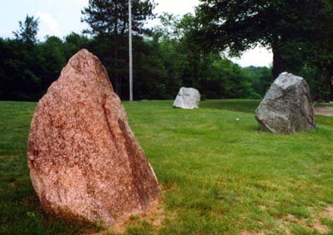
The Druid Hill Stone Circle is not a "circle," and
there is no "ring" of stones. Rather, it is an east-west axis tear-drop
shape with five stones clumped at the eastern tip, and three stones ranged at
the western butt-end. The entire mound is ringed with a ten foot wide
flattened moat-like area of earth, which has been obliterated on the northern
side by the access road. According to Dot Hayden's report on the
Environmental Archeology Group's excavation,
there is also a low ring of paving stones laid end to end around the mound.
This was discovered under 6 inches of topsoil. Where this ring is in
relation to the ten foot wide flattened area that surrounds the mound is
unclear.
Furthermore there are two stones at the western butt-end
of the tear-drop that are outside the area of the mound. The northern one
is a flat table-like stone, and the southern one is a seven foot tall
needle-shaped stone, which was toppled by vandals around 1988 or 1989. The
Institute considers both these stones "recumbent," but it is unclear to me if
the table-like stone was ever standing. It does not appear to have a shape
that can be stood in any other position then the one it is in.
A significant unreported feature of the mound is that
it has large low symbols on its top built of earth. There is a large
crescent shape that cradles a circular shape. The circle is approximately
nine feet in diameter, and the crescent about 4 feet wide at it widest point,
and about 20 feet from tip to tip. The crescent is towards the western
butt-end of the mound, and the circle is in the middle of the mound. The
height of the symbols, back in 1984, was about 1" tall. The symbol shapes
are suggestive of the sun and a crescent moon.
Due to weathering, however, the circle and crescent
shapes can only be readily discerned in late winter/early spring in slanting
light when the snow is gone and the earth is hard and frozen.
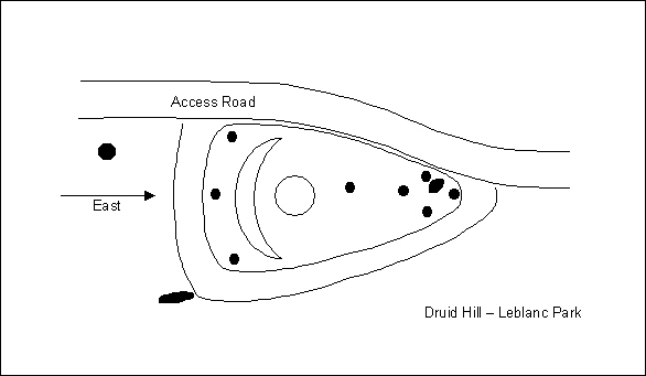
The 11 small black circles are stones
The inner oval is a mound, outer oval is extent of
moat.
The Crescent and large circle are moon and sun
symbols.
Weird Experiences at Druid Hill
My original interest in Druid Hill back in 1984 is
perhaps a bit frou-frou in hindsight. Having visited Mystery Hill ("America's
Stonehenge") and liking the theory that the Celts had colonized New
England and created lithic structures, I was very pleased to believe that the
Druid Hill structure was a mystical Celtic artifact. In this mind-frame, I
would often meditate at the stones (as best I could - the place was crawling with
playground kids on Big Wheels). But I do not recall any especially unusual
experiences in doing so.
However, one occasion bears the merit of the telling.
Myself and two friends had gone to the park and visited the stones one autumn
evening in 1984. For reasons unclear to me at this point we engaged in the
following activity: I stood in the center of the mound on the circle and
did a special meditation while my two friends stood off to the side to observe.
I can't imagine meditation as a spectator sport, but there you have it.
Only golf could be worse. As far as I recall, I experienced nothing
untoward or unusual during the meditation, which really didn't last for more
than 10 minutes. However, upon rejoining my friends, they were all agog
with the revelation that I had "disappeared" for a goodly length of time -
upwards of 20 to 30 seconds. They described it that I simply disappeared
for half a minute and then reappeared - blinked out and blinked back in later.
Again, I did not experience anything of that nature from my vantage point.
Being quite impressed with myself, I invited my
brother-in-law who lived in Lowell to take a look at the mound on November 5 of
the same year. While there I asked him to stand to the side of the mound
and observe me and report on anything that might happen. I then scurried
to the circle in the middle of the mound and did my special meditation, again
for about 10 minutes. He had no prior knowledge of what had happened
previously or what I was doing. And yet, he quite excitedly reported that
I had vanished instantly and later reappeared, only to fade out slowly and fade
back in again.
My brother-in-law has since passed away, but I have kept in touch with one of
the initial episode people (Scurv
Dawg), and he swears on his Scurv Dawg honor to this day that I really did
disappear. I have no idea what actually happened those two nights, but as far as
I know, I have never "disappeared" since, although there have been plenty of
times I wish I could have.
I have also kept an ear to the wall over the years for
any other odd happenings at Druid Hill, but have heard of none.
Ouija Boards
And while I'm at it, I can't help but note the
superficial resemblance between the shape of the mound and a ouija board
planchette. They are both the same shape, the stones are in the same positions
as the planchette's tripod legs, the center circle resembles the viewing hole,
and they both have a mystic symbol: the crescent on the mound, and the
circle-star on the planchette.
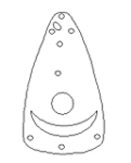
Mound
Planchette
The first commercial ouija board was patented and in
production by 1891, well positioned to capitalize on the spiritualism craze that
exploded in the 1860's. The commercially sold ouija boards may well have
been the inspiration of the mound design. Certainly, the timeframe fits.
Ouija boards were sold beginning in 1891, and the mound was dated to
approximately 1900. (Ouija
board History)
However intriguing this visual resemblance is, I can
not think of a single reason other than eccentricity to create such an expensive
monument to the Ouija Board, nor how such an outrageous effort in 1900 era
Lowell could have gone unremarked and unremembered.
And this is a good point - if it is of the 1900 era
construction that the excavation indicates, then how did such an oddity go
unremarked and unremembered? Perhaps some time spent in the archives of
the Lowell newspaper of the day would reveal a mention or two of its
construction.
Conclusions / Questions
My opinion today about Druid Hill pretty much squares
with Dot Hayden's account of the Environmental Archeology Group's findings: that it is a turn of the century folly built for
reasons unknown. I have not been able to track down the sources that
presented me with Druid Hill information back in 1984. So, as suggestive
as these accounts are, I don't feel that without finding them again and asking
them to go on record and/or document their stories, that these accounts are
currently worth more than travelers tales. I feel that the excavation was
reasonable proof that the site is a modern construction.
However, not everyone at the American Institute For
Archeological Research felt that the
1985 Environmental Archeology Group's excavation closed the door on the origins of the site. Dorothy Hayden
concludes her article as follows:
"The story should end there. But there are some among
us who are not completely satisfied with this verdict. Questions remain
unanswered. Why do the monoliths themselves show such extensive weathering;
sufficient for a geologist to estimate that they have been exposed to the
elements in their present form for a thousand years. Why is the working of the
stones so crude and ancient in appearance? And who had the knowledge, and went
to the trouble to recreate, a typical Celtic stone circle complete with many
astronomical alignments common to them?
"Also, why the cryptic references to the site as Druid
Hill long before the stone circle was ever set in its present position? There
is one more tantalizing fact: the Varnum family, who acquired this tract of land
in 1667, had a reputation for buying property on which there already existed at
the time of purchase strange stone constructions of unknown origin.
"For some of us, the riddle remains unanswered."
Maps
These are various maps and aerial photos of the Druid
Hill Stone Circle location. Note that the site borders on the Indian
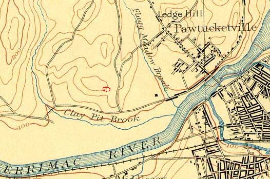
Reservation in the 1659 map. Also, the Isolation Hospital in the 1941 map
is in the same place as the pool is now (1987 map) - exactly as my source said
it was. (However, this doesn't prove that the circle was previously at the
hospital/pool location.)
Also, the maps appear to show that the road to the
Isolation Hospital - with the exception of the street entrance - follows the
same route today as it did then. Bearing in mind that the "moat" around
the mound has the access road running through its northern length, this would
indicate that the mound was there before the road.

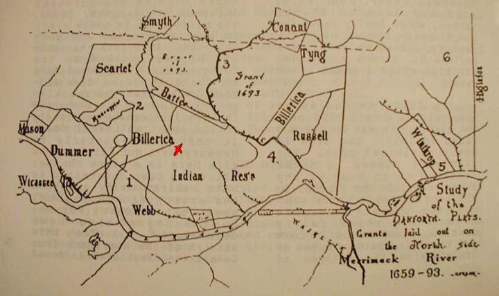
Land Grants in Lowell 1659 - 1693
Druid Hill is marked with an "X"
Note that the site was in an area marked at the
time Indian Reservation.

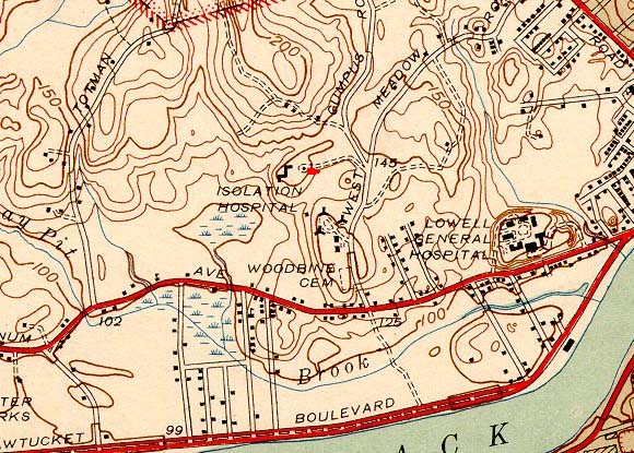
1893 Topographical Map - Druid Hill Stone Circle
in Red

1941 Topographic Map - Druid Hill Stone Circle
Marked in Red
structure to left of the circle is the hospital

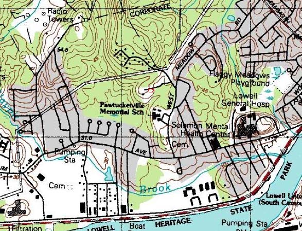
1987 Topographical Map - Druid Hill Stone Circle
Marked in Red
black dot to left of the circle is the pool

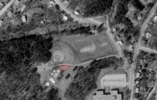
1987 Aerial Photo of Leblanc Park - Druid Hill
Stone Circle in Red
Links
The Institute of Urban Speleologic Studies & Archeology's
Druid Hill Webpage.
Abandoned, strange, historic, haunted & just plain interesting
places
Standing-Stone
Cluster in Eastern Massachusetts
Science Frontiers Online No. 40: Jul-Aug
1985
Documents
The following are documents that pertain to Druid
Hill.
The quotes by John Pendergast are from:
On Site: A publication of the American Institute For
Archeological Research, Inc.
The Druid Hill Stone Circle In The Context of Early
Western European Literature
By John Pendergast
Volume One, Number Two, August, 1985
The quotes by Dorothy Hayden are from:
On Site: A publication of the American Institute For
Archeological Research, Inc.
The Druid Hill Story
By Dorothy L. Hayden
Volume One, Number Three, June 1987
The American Institute For Archeological Research is
now defunct. Dorothy Hayden is deceased, and I can not locate John
Pendergast.
The full transcript of The Druid Hill Story by
Dorothy L. Hayden is as follows:
In a public park in Lowell, Massachusetts,
incongruently flanked by modern play ground equipment and a swimming pool,
sits an enigmatic stone circle looking as old as Time itself. James
Pendergast [of Lowell University], the Institutes chief Archeologist, who has
excavated in the British Isles, became intrigued with this construction.
The Druid Hill Stone Circle consist of a raised
tear-drop shaped mound approximately one meter high, with a dozen monoliths
ranged about it in a pattern typical of stone circles all over the British
Isles. At the western end, on level ground below the raised mound, lies a
large flat recumbent stone and top the southwest stands a huge outlier
monolith, both typical of European stone circle construction.
No written recode of who built this mound and
megalithic complex, when or why it was built, appears to exist. In the memory
of elderly residents of the vicinity it has always been there. Coupled with
this are the tantalizing references in old documents, first to Bridgets Hill
(the name Bridget being associated with witches), and then to Druid Hill.
The locality of Druid Hill has an odd history; first
mentioned as field pasture on the edge of an Indian reservation in 1659, it
was acquired by Samuel Varnum in 1667 and remained in his family for 250
years. In 1906 a health camp was built on land directly adjacent to the stone
circle site. By 1916 work was begun upon a (tuberculosis) isolation hospital
on the land next to the stone circle site. This isolation hospital was opened
in 1918 (two years before schedule because of the devastating influenza
epidemic that was raging through the area at the time). The hospital was
razed in 1953 ands the land became a public park. This part of the sites
history is fairly well documented, but there is never any mention of the
standing stones.
Basically, there are two logical possibilities: the
stone circle could have been built as a folly or fraud in post-colonial
times; or it could have been built in pre-Columbian times by either indigenous
Amerindians or by Europeans.
A great deal of time and effort went into
preliminary research, securing funding and obtaining personnel for the
proposed Druid Hill Dig. Eventually all requirements were met and an
excavation permit was issued. On May 4, 1985 a grid was laid out and
excavation was begun by a group consisting of students, volunteers, Institute
Members and technical advisors. For eight consecutive Saturdays we dug in
sunshine and in rain. Druid Hill finally began to yield up some of its
secrets.
Beneath a tough layer of sod the soil held a great
quantity of artifacts. At first, twentieth century trash, so typical of a
public park. Next came bits and pieces of china, bottle glass and fragments
of clay pipes; all dateable to the 19th and early 20th
centuries. Mixed in were fragments of laboratory glass which appeared to date
from the time when the site was occupied by the isolation hospital.
Pits driven into the center of the mound reveled
thick layers of striation containing ashes, burned rubbish, cinders etc.,
indicating that the mound itself had been created by piling on truck loads of
fill and perhaps also scraping fill into it from nearby locations.
Pits were excavated to depths of from 60 cm. to 188
cm. And all ended abruptly in sterile sand which appeared to be the ancient
outwash of glacial till from the nearby Merrimack River.
Finally a pit was driven beneath the monolith
designated Number One. Carefully the soil was scraped away to reveal a socket
of paving stones, datable to approximately 1900, in which the base of the
monolith rested. Excavation of several of the other monoliths revealed the
same pattern; sockets made of paving stones. Under the outlier stone a red
brick had been used to chink a cavity between the paving stone props and the
irregular base of the standing stone.
Also several pits driven around the perimeter of the
mound disclosed an odd little wall consisting of paving stones laid end to
end, on edge in a single file around much of the mound at a depth of 15 cm.
The answer to the riddle of the stone circle seemed
evident. The mound was created and the monolith were undoubtedly set in their
present position in the paving stone sockets within a few years of the turn of
the last century. By whom and for what purpose is still unknown.
The story should end there. But there are some
among us who are not completely satisfied with this verdict. Questions remain
unanswered. Why do the monoliths themselves show such extensive weathering;
sufficient for a geologist to estimate that they have been exposed to the
elements in their present form for a thousand years. Why is the working of
the stones so crude and ancient in appearance? And who had the knowledge, and
went to the trouble to recreate, a typical Celtic stone circle complete with
many astronomical alignments common to them?
Also, why the cryptic references to the site as
Druid Hill long before the stone circle was ever set in its present position?
There is one more tantalizing fact: the Varnum family, who acquired this tract
of land in 1667, had a reputation for buying property on which there already
existed at the time of purchase strange stone constructions of unknown
origin. For some of us, the riddle remains unanswered.
About the American Institute For Archeological
Research:
The now defunct American Institute For
Archeological Research, run by Leon Morrill and Dot Hayden, was an early
1980's disgruntled offshoot of James Whittall's Early Sites Research
Society (now defunct) and the New England
Antiquities Research Association.
Although the text of Dot Hayden's Report makes it
seem as though the Druid Hill excavation was an Institute organized event,
this is incorrect. Rather, it was conceived and coordinated by James
Pendergast of the University of Lowell (who was also an advisor for the
Institute, hence his reference in the article). James independently
obtained the excavation permit and funding from the Massachusetts Historical
Commission, and had the actual dig conducted and performed by the
Environmental Archeology Group. Some Institute members did participate
in the excavation, but it was not an Institute organized event.
The Environmental Archeology Group included:
Dr. Gorman Principal Investigator
John Pendergast Project Archeologist
Dr. Virginia Ross Geology, Topology, and Flora
Charles Panagiotakos Hydrology
Edward McManus Metal Conservator
Dr. Richard Warren Archaeoastronomy
Ronald Dalton Chief Excavator
James Whittall's (Early Sites Research Society)
impressions of Druid Hill:
"Driving up the roadway into LeBlanc Park in February
1984, I saw a sight I had not seen since my travels in the British Isles.
Situated on a mound was a cluster of weathered megalithic stones. I was
filled with disbelief -- it just couldn't be -- someone was having fun with
my senses; Western Europe, yes, but here, in Massachusetts, no. The reality
of the scene before me was very difficult to focus on, the parallel with
sites I had seen in Scotland and Ireland was astonishing."
James P. Whittall II: A Cluster of Standing Stones on
Druid Hill, Lowell, Massachusetts Early Sites Research Society
Bulletin, 11:19, No. 1, 1984.
Email Daniel V.
Boudillion
Back to Field
Journal
All Images & Text Copyright © 2005 by Daniel V. Boudillion
(unless
otherwise noted)
|